Skip to product information
1 of 1

GARMIN

Garmin Montana 760i – Rugged GPS Touchscreen Navigator with inReach Technology and 8-megapixel Camera – 010-02964-10

Garmin Montana 760i – Rugged GPS Touchscreen Navigator with inReach Technology and 8-megapixel Camera – 010-02964-10

SKU:010-02964-10

Regular price $764.99
Regular price Sale price $764.99
Sale

FREE SHIPPING on orders $100+

Large freight items excluded. View Shipping Policy

Size
View full details

Garmin · Handhelds

Off-grid navigation and messaging with built-in camera

The Garmin Montana® 760i in the Rugged GPS Touchscreen Navigator with inReach® Technology and 8-megapixel Camera configuration combines advanced navigation, global satellite communication, and on-device photo capture in a durable 5-inch handheld format.

Designed for adventures that go beyond cellphone coverage, it suits navigation on foot, bike, kayak, ATV and more. Preloaded routable topographic mapping, satellite imagery downloads over Wi-Fi®, and turn-by-turn street guidance help keep routes clear and easy to follow. When it’s time to share progress or ask for help, inReach features support two-way messaging and interactive SOS with an active inReach subscription, while the integrated 8-megapixel camera automatically geo-tags photos for location context.

  • Part Number010-02964-10
  • Display TypeWVGA transflective, dual orientation
  • Battery lifeUp to 24 hours
  • Water ratingIPX7

Connectivity

inReach global connection

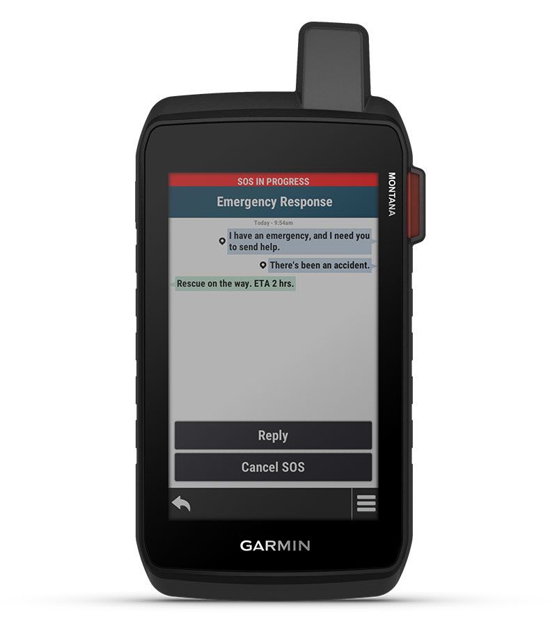
With an active inReach subscription, Montana® 760i supports two-way messaging, location sharing, and interactive SOS alerts through the 100% global Iridium® satellite network. It’s built for off-grid communication without relying on cellphone coverage, and supports features such as group messaging, exchanging locations with other inReach devices, and MapShare compatible tracking.

Garmin Montana 760i – Rugged GPS Touchscreen Navigator with inReach Technology and 8-megapixel Camera – inReach global connection

Display

Big, glove-friendly display

A 5-inch WVGA transflective touchscreen is designed for outdoor use and supports dual orientation, making it easy to view mapping and data in different positions. The chemically strengthened glass lens adds durability, and the interface supports high-speed USB-C for charging and data connections.

Garmin Montana 760i – Rugged GPS Touchscreen Navigator with inReach Technology and 8-megapixel Camera – Big, glove-friendly display

Navigation

Maps plus satellite imagery

Navigate with preloaded routable topographic mapping and City Navigator® street mapping, then add detail with subscription-free, high-resolution satellite imagery downloads over Wi-Fi® connectivity. The device also supports adding maps and offers 32 GB of onboard memory, with external storage support for a 32 GB max microSD™ card.

Garmin Montana 760i – Rugged GPS Touchscreen Navigator with inReach Technology and 8-megapixel Camera – Maps plus satellite imagery
Garmin Montana 760i – Rugged GPS Touchscreen Navigator with inReach Technology and 8-megapixel Camera – Rugged handheld for real travel

Rugged handheld for real travel

Montana® 760i is built to handle demanding conditions, with testing to meet MIL-STD 810 for thermal, shock, water and vibration and an IPX7 water rating. Its handheld design pairs a large touchscreen with a durable build, and it’s compatible with a variety of robust mounting solutions (sold separately) to adapt the navigator for different activities and vehicles.

Garmin Montana 760i – Rugged GPS Touchscreen Navigator with inReach Technology and 8-megapixel Camera – Navigate with sensors and multi-GNSS

Navigate with sensors and multi-GNSS

For confident guidance on varied terrain, the device supports GPS and Galileo, along with ABC sensors including an altimeter for elevation data, barometer to monitor weather and a tilt-compensated 3-axis electronic compass. Preloaded maps help show terrain features and landmarks, and TracBack® and point-to-point navigation support practical routing when it’s time to retrace or change course.

Garmin Montana 760i – Rugged GPS Touchscreen Navigator with inReach Technology and 8-megapixel Camera – Capture and tag the moment

Capture and tag the moment

The built-in camera records images at 8 megapixel and supports automatic geo-tagging, helping tie photos to the places where they were taken. Combined with mapping and waypoint tools, it becomes easier to document key landmarks, trail junctions, camps, or points of interest for later reference or trip review.

Product Video

Specifications

Part Number 010-02964-10
Model Montana® 760i
Configuration Rugged GPS Touchscreen Navigator with inReach® Technology and 8-megapixel Camera
Lens material Chemically strengthened glass
Dimension 3.6" x 7.2" x 1.3" (9.19 x 18.30 x 3.27 cm)
Weight 14.5 oz (410 g) with included lithium-ion battery pack
Water rating IPX7
MIL-STD-810 Yes (thermal, shock, water, vibe)
Display Type WVGA transflective, dual orientation
Display Size 2.55"W x 4.25"H (6.48 x 10.80 cm); 5" diag (12.70 cm)
Display resolution 480 x 800 pixels
Battery Type Rechargeable lithium-ion (included)
Battery life GPS Mode: up to 24 hours; GPS Mode with a text message or location sent every 10 minutes: up to 24 hours; Expedition Mode: up to 440 hours; Expedition Mode with a text message or location sent every 30 minutes: up to 400 hours; Powered Off: up to 1 year; Note – Battery life estimates are with full sky view and can be significantly impacted by obstructions or tree cover.
Memory/History 32 GB (user space varies based on included mapping)
Interface High-speed USB-C

In the Box

Montana 760i
High capacity lithium-ion battery pack
USB cable
Documentation

Connectivity & Subscriptions

Interactive SOS Yes
Weather Yes
Send and receive text messages to SMS and email Yes
Send and receive text messages to other inReach device Yes
Send and receive group messages Yes
Exchange locations with other inReach device Yes
MapShare compatible with tracking Yes
Virtual keyboard for custom messaging Yes
Send waypoints to MapShare during trip Yes
Send route selection to MapShare during trip Yes

NOTICE: Some jurisdictions regulate or prohibit the use of satellite communications devices. It is the responsibility of the user to know and follow all applicable laws in the jurisdictions where the device is intended to be used.

Features at a Glance

General Touchscreen
Maps & Memory Ability to add maps, Basemap, Automatic routing (turn by turn routing on roads) for outdoor activities, Automatic routing (turn by turn routing on roads) for motorized vehicles, Includes detailed hydrographic features (coastlines, lake/river shorelines, wetlands and perennial and seasonal streams), Includes searchable points of interests (parks, campgrounds, scenic lookouts and picnic sites), Displays national, state and local parks, forests and wilderness areas, Rinex logging
Sensors GPS, Galileo, Barometric altimeter, High-sensitivity receiver, GPS compass (while moving)
Daily Smart Features Connect IQ™ (downloadable watch faces, data fields and apps), Smart notifications on handheld, Weather forecasts, Weather, Compatible with Garmin Messenger app, VIRB® Remote, Pairs with Garmin Connect™ mobile
Safety and Tracking Features LiveTrack
Tactical Features Ballistics solver, XERO™ Locations
Outdoor Recreation Area calculation, Fish forecast, Sun and moon information, Picture viewer, LED beacon flashlight
Mapping & Navigation Point-to-point navigation, TracBack®
Outdoor Applications Compatible with Garmin Explore™ app, Garmin Explore website compatible, Smart switching between Wi-Fi, Cellular and Satellite with Garmin Messenger app

Additional Specifications

Maps & Memory
Preloaded maps Yes (TopoActive, by region; City Navigator, North America)
Map segments 15,000
Satellite imagery Yes (direct to device)
External memory storage Yes (32 GB max microSD™ card)
Waypoints/favorites/locations 10,000
Courses 250, 200 course points per course
Tracks 250
Navigation Track Log 20,000 points, 250 saved gpx tracks, 300 saved fit activities
Navigation Routes 250, 250 points per route; 50 points auto routing
Outdoor Recreation
Geocaching-friendly Yes (Geocache Live)
Custom maps compatible Yes (500 custom map tiles)
Camera Yes (8 megapixel; automatic geo-tagging)

Important Information

Active satellite subscription required. Some jurisdictions regulate or prohibit the use of satellite communication devices. It is the responsibility of the user to know and follow all applicable laws in the jurisdictions where the device is intended to be used.

When used with your compatible smartphone and the Garmin Messenger™ app or when used with your compatible inReach technology-enabled Garmin device

Wi-Fi is a registered trademark of the Wi-Fi Alliance. USB-C is a registered trademark of USB Implementers Forum. Satellite Imagery © 2026 Vantor (date of satellite imagery may vary).

⚠️ WARNING: This product can expose you to chemicals including lead and phthalates, which are known to the State of California to cause cancer and birth defects or other reproductive harm. Learn more.